
A printed guidebook starts ageing the day it leaves the press. A car park turns paid, a trail gets fenced off. The earliest you can correct that is the next edition, two years later — if there is one at all.
Lofoten Photography — Under Arctic Light takes a different approach. Every one of its 86 numbered spots carries a QR code, 29 × 29 mm, top right of the page. It points to a permanent address whose contents I can change at any time. If access to a spot changes tomorrow, the update is live within minutes on every copy of the book — whether you bought it last week or will buy it in two years.
The same goes for features that didn’t exist when the book went to press. The book came out in June. Since then the app has gained a free demo anyone can open, light times calculated for Arctic latitudes rather than mid-European ones, the moon, an answer about the northern lights, and a lot of polish on the handling. All of it arrived on the addresses already printed in the book. Nobody had to buy anything twice.
What’s on a spot page
What stays the same
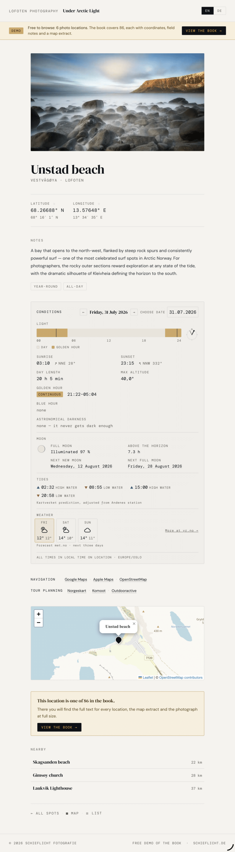
- GPS coordinates, in decimal degrees and degrees/minutes/seconds, tap to copy
- Elevation, where it matters
- A short description, tags, a photo
- A warning field for anything current — a closed trail, construction, a changed access point
- Direct links for getting there (Google Maps, Apple Maps, OpenStreetMap) and for planning the terrain (Norgeskart, Komoot, Outdooractive)
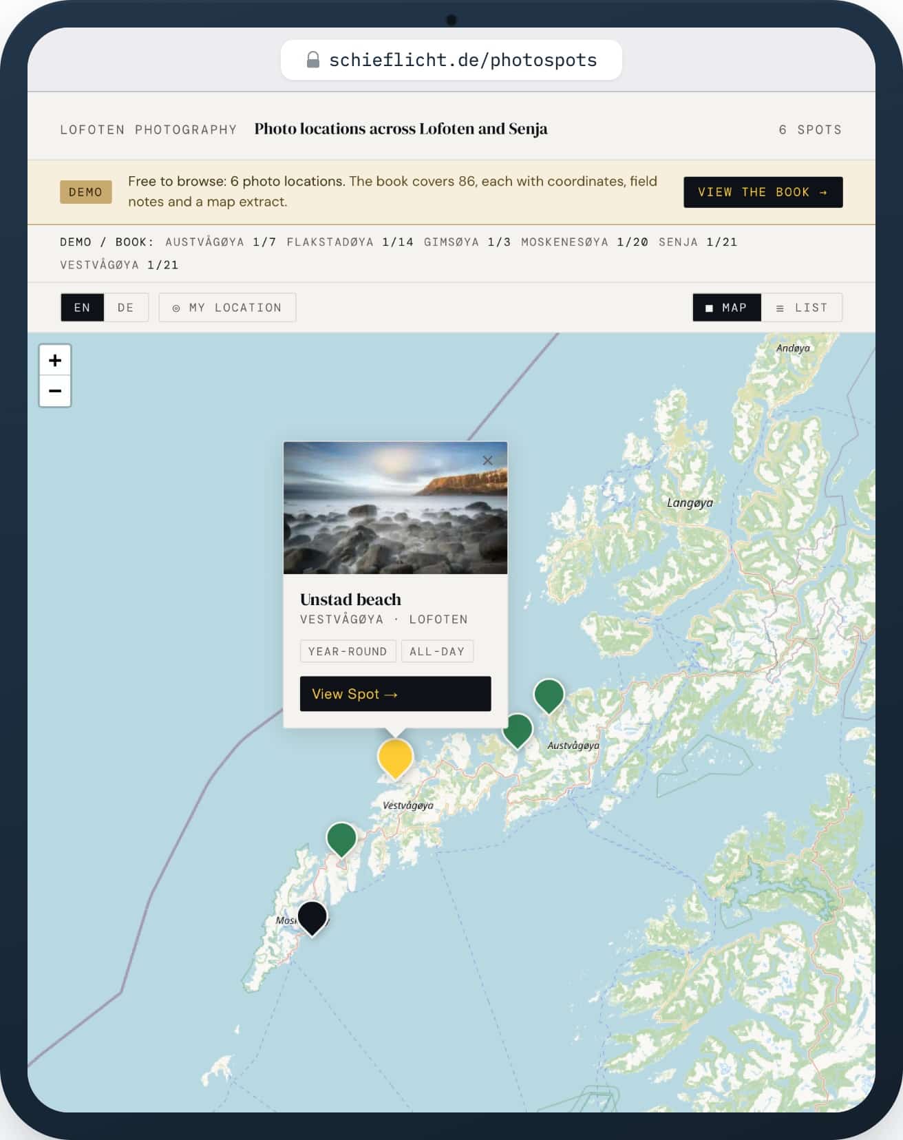
- An overview map and list, filterable by island and by tag — season, time of day, conditions. The full 86-spot list is searchable by name, tag or island as well.
- A search for spots near wherever you’re currently standing
What changes with the date
- Weather for the day you’re planning around, plus tides wherever the Norwegian tide service reaches the spot
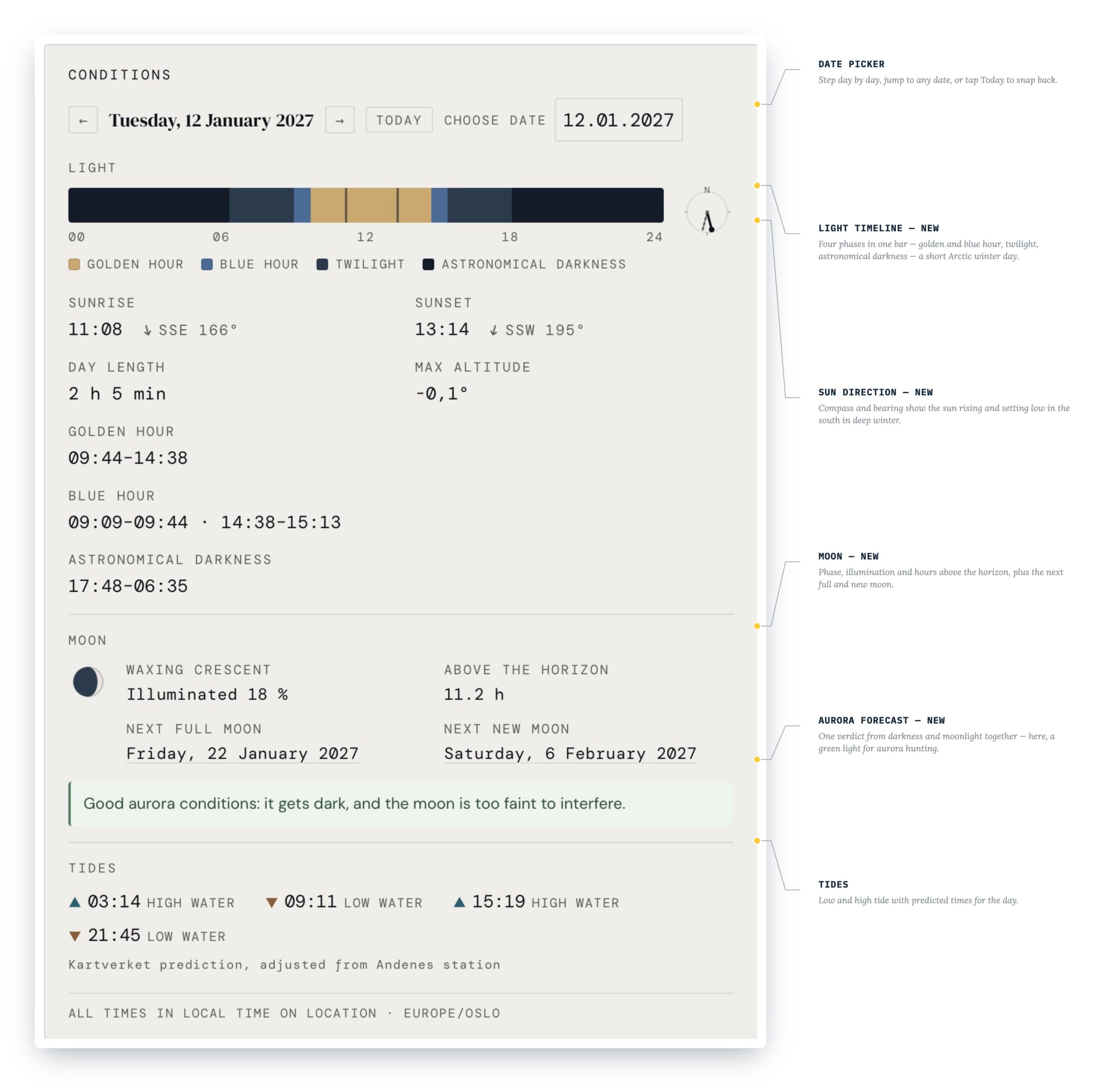
- Light times for any date — sunrise, sunset, blue hour, golden hour — on a single bar you can read at a glance, with the sun’s compass direction beside it
- Moon phase, how full it is, and how many hours it stands above the horizon that day, plus the next full and new moon
- One line telling you whether it’s dark enough for the northern lights — and whether the moon will wash them out anyway
The last five of those weren’t there in June.
Tides often decide what kind of photograph is even possible at a spot. At Skagsanden, low tide leaves the sand wet and mirror-flat — the shot the beach is known for. At high tide, the water reaches up to the rocks beside the car park, and those become a foreground of their own: a completely different photograph from almost the same spot. Every spot page carries the nearest tide prediction, wherever the Norwegian tide service reaches that far.
Light that understands the Arctic
What that means in practice
A few examples, all calculated for Hamnøy bridge, 67.93° N, and checked against the 2026/27 season:
- 25 July — golden hour runs continuously from 21:39 to 04:51, seven hours straight. The sun never drops below −4°, so there’s no blue hour at all that day.
- 12 January — sunrise 10:57, sunset 13:35. The sun climbs to just +0.3°. Golden hour runs 09:42 to 14:50, a good five hours, because the sun never leaves the golden band all day. Sunrise and sunset both fall inside it.
- 21 December — polar night, and the sun doesn’t rise. There is golden light anyway, from 10:07 to 14:06, the sun staying just below the horizon the whole time.
- 27 May to 16 July — midnight sun in Reine. Even then there is golden light, at midnight.
All times are Norwegian local time, not yours. Planning from home in January, you want the time on the ground, not the time on your phone.
You can check this yourself, though only for the next few days: open Hamnøy bridge in the demo and move the date. The demo reaches five days forward and back, and there’s an unpleasant reason for the limit — a bot network was harvesting these date pages, around 2,300 hits on a single day in September. The window used to be three months wide, and that width was the bait. The winter examples above can’t be reproduced in the demo, then. The spot pages from the book have no such limit: any date works there, five years in either direction.
The moon, and what it means for the aurora
At Hamnøy bridge the moon is 91% lit and up for a full 24 hours on 21 December. On 25 July it is 84% lit and never rises at all. An ordinary moon app reports both nights as bright and is badly wrong about one of them.
The aurora line
That hour count feeds the aurora line on each spot page, because a near-full moon overhead all night washes out an aurora as thoroughly as a light sky does. The line says one of four things: properly dark with no moon up; dark, with the moon too faint to matter; dark enough, but lit all night by the moon anyway; or simply not dark enough at all.
Run the 200 nights from 1 September at a spot like Skagsanden and a good three in ten come out properly dark and moonless, more than half moonlit, and about one in eight with only a crescent too thin to matter. Not one night in that stretch is too bright — those all fall in summer.
Which brings up the uncomfortable answer that saves a wasted trip: for months in summer there is no astronomical darkness at all, and without it the northern lights stay invisible no matter how high the reported activity.
That line now sits on every spot page, including the ones without a northern-lights tag. The tag says something about the subject — an open view north, a usable foreground — not about the night, and whether the night is any good can be worked out the same way anywhere. Tides are different: Hamnøy bridge is the only one of the six demo spots the Norwegian tide service doesn’t reach, and the other five carry the prediction on the page. Open any of them, pick a date, and read the verdict for yourself.
Smaller things that add up
Not everything since June has been a headline feature. Reading the app on a phone got noticeably better, with stronger contrast and sharper type — which matters rather more when you’re squinting at it in the dark with cold hands. Moving between spots is simpler. There’s a search for spots near wherever you happen to be standing, useful when the weather sends you somewhere other than where you planned. The full 86-spot list gained a search field for names, tags and islands. And the date now follows you: click a day in the weather strip and the whole page — light, tide, moon — moves with it, then stays put when you jump to a neighbouring spot or switch between English and German.
Since August most of the work has gone into the phone. Filters and dropdowns now slide up from the bottom instead of covering the map. The bars top and bottom are slimmer, and the legend folds away after your first visit. The map can be switched to Kartverket’s topographic sheet, with contour lines, trails and huts. And if you save the map to your home screen, you now get a proper icon instead of a screenshot.
None of it required a new edition of the book.
Try it yourself
| Island | Spot |
|---|---|
| Senja | Tungeneset |
| Austvågøya · Lofoten | Laukvik Lighthouse |
| Gimsøya · Lofoten | Gimsøy church |
| Vestvågøya · Lofoten | Unstad beach |
| Flakstadøya · Lofoten | Skagsanden beach |
| Moskenesøya · Lofoten | Hamnøy bridge |
I picked well-known spots on purpose: anyone researching Lofoten will come across them anyway. The other 80 are in the book.
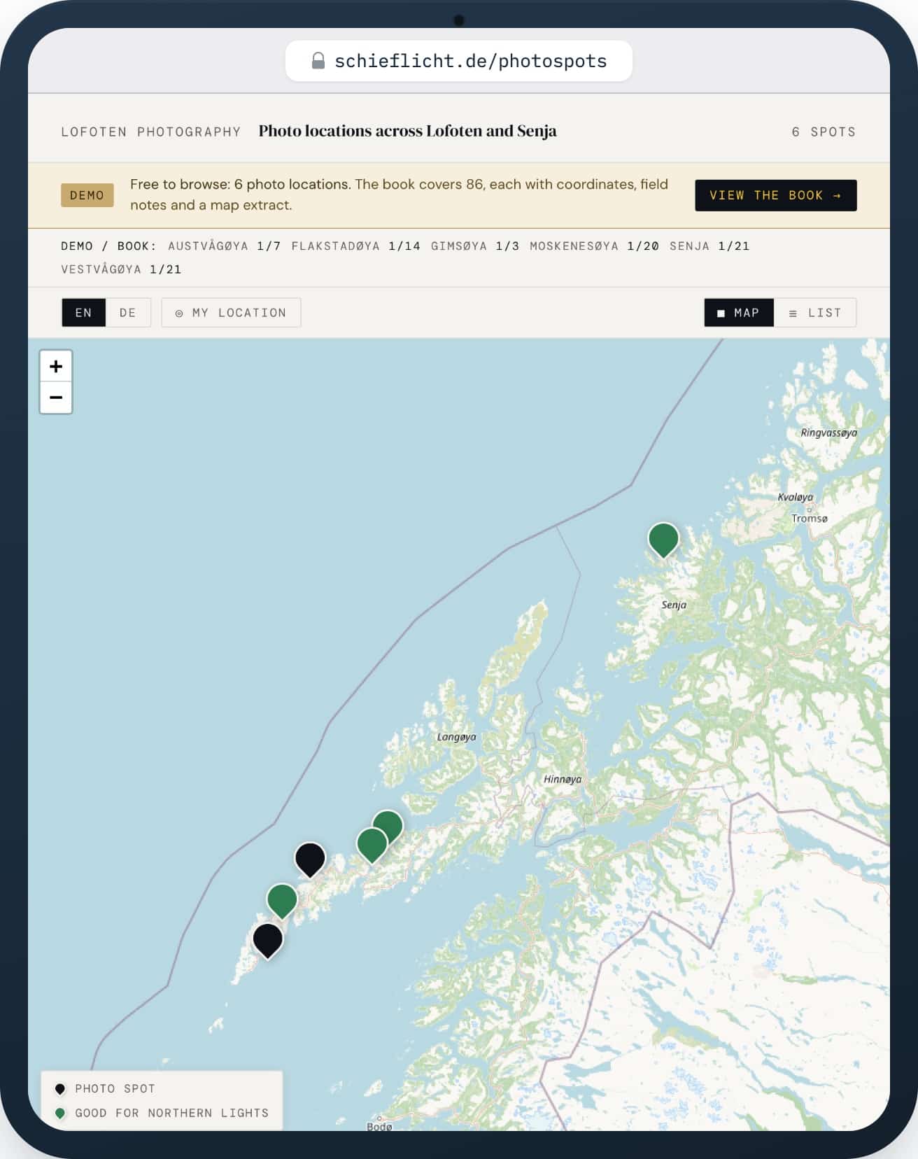
The six demo pages are the real thing, exactly as book readers see them. Two things do differ. The list around them is smaller — at six spots there’s nothing to filter or search through, so those tools live in the full version. And the date only moves five days forward and back; through the QR code in the book, any date works.
What it isn’t
The app doesn’t replace the book, and it was never meant to. The entries online are deliberately short: coordinates, tags, a couple of lines. The full text, the map excerpt, the photo at full size — that’s what the book is for.
How to get full access
Feedback appreciated
Something missing, or not working the way you’d expect? I’d like to know — leave a comment below, or get in touch directly.